| |
 * As a professional
sailor and weather router, I can advise and help people
with all aspects of route planning and passage weather.
From 1985 to present I sailed professionally as an
offshore sailing instructor and delivery captain. For 20
years I essentially lived at sea, teaching others the art
and science of safe, efficient, coastal and offshore
passagemaking. I have written an a practical 200 page,
illustrated text/workbook. To date I have taught over 500
adult students the elements of vessel preparation,
weather routing and offshore passagemaking. Together with
my many crews, I have sailed all over the Western
Atlantic, Caribbean and Gulf of Mexico, including
transAtlantic. In 20 years I have accumulated over
150,000 nm at sea which is about seven times around the
world. * As a professional
sailor and weather router, I can advise and help people
with all aspects of route planning and passage weather.
From 1985 to present I sailed professionally as an
offshore sailing instructor and delivery captain. For 20
years I essentially lived at sea, teaching others the art
and science of safe, efficient, coastal and offshore
passagemaking. I have written an a practical 200 page,
illustrated text/workbook. To date I have taught over 500
adult students the elements of vessel preparation,
weather routing and offshore passagemaking. Together with
my many crews, I have sailed all over the Western
Atlantic, Caribbean and Gulf of Mexico, including
transAtlantic. In 20 years I have accumulated over
150,000 nm at sea which is about seven times around the
world.Our open ocean passage weather and
ocean current analysis involves significant resources and
knowledge. It involves analyzing historical, present
weather, forecast passage weather, and ocean currents and
with some knowledge of the vessel, equipment, crew and
desired destination, advising the skipper as to upcoming
weather events, alternative strategies, and if
appropriate a specific optimal route plan. The route plan
should consider the vessel's resources, weather,
currents, avoiding hazards, maximizing boat speed,
safety, comfort, etc. Weather forecasting and route
optimization strategies rely heavily on sophisticated
computer models to predict weather, seas and ocean
currents many days ahead. However computer models, even
as powerful as they are, are not infallible. To trust
their outputs one must compare the output with what
trained meteorologists believe will happen and compare
any computer model forecast data with that of one or more
other computer models. We will look for not only the
forecast but also consistency between the various
forecast resources.
At my
office in Naples, Florida, I have high speed internet
access to the major US and World Meterological
Organization weather services and I operate a Marine
Private Coast Station. Every day I am looking at NOAA
coastal, offshore and highseas forecasts, satellite
imagery, forecast imagery (synoptic, surface, and upper
air). Every day I have instant access to weather
forecasts generated by NCEP's and US Navy's global and
regional computer models. The NCEP's models I use include
the GFS, RUC, NAM, WWIII and NGM. The US Navy's models
include the NOGAPS and COAMPS models. The UK has an
excellent model which I check often the ECMWF. Some
universities with meteorology programs have developed and
maintain NWP models. Penn State and the University of
Wisconsin have excellent online weather data. Every
weather model has it's own blind spots, strengths and
weaknesses, so no one model by itself should be relied
upon with certainty. Some models have great long range
predictive capability of from 8-16 days. Other models are
more near term, 24-72 hours. Some are global in scope,
whereas others are regional in scope or even country
specific. Some are very high resolution. Others are low
to medium resolution.
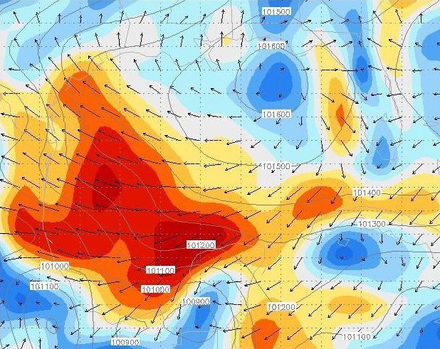 At the right is a
sample image from the NCEP GFS model. The GFS model is a
global model, with excellent 3-5 day predictive
capability. The model's "resolution" or minimum
unit of area for showing weather variables, is a 54
kilometers (about 28 nautical miles). This is very good
resolution, especially compared to standard marine
forecasts or weatherfax charts. The GFS model can provide
detailed forecast data for any one or more of up 150
different weather variables, to 16 days. It is also a
global model, meaning it is used by meteorologists to
forecast weather globally. It is quite accurate to 3-4
days, less accurate to 5-6 days, and useful to 8-10 days.
At times the GFS model may not perform as well as other
models (such as the ECMWF, NAM, or NGM), in predicting
tropical storm tracks, convection based activity, frontal
development or near coastal weather. offshore weather At the right is a
sample image from the NCEP GFS model. The GFS model is a
global model, with excellent 3-5 day predictive
capability. The model's "resolution" or minimum
unit of area for showing weather variables, is a 54
kilometers (about 28 nautical miles). This is very good
resolution, especially compared to standard marine
forecasts or weatherfax charts. The GFS model can provide
detailed forecast data for any one or more of up 150
different weather variables, to 16 days. It is also a
global model, meaning it is used by meteorologists to
forecast weather globally. It is quite accurate to 3-4
days, less accurate to 5-6 days, and useful to 8-10 days.
At times the GFS model may not perform as well as other
models (such as the ECMWF, NAM, or NGM), in predicting
tropical storm tracks, convection based activity, frontal
development or near coastal weather. offshore weather
If you
would like additional information on the computer models
we at Ocean-Pro Weather use, here are two helpful links.
The first is the UCAR / NCEP NWP weather models info page. The
second is the NHC's TPC (Tropical Prediction Center), NWP Tropical storm
models info page.
With our
excellent weather forecasting and route planning tools.
We at Ocean-Pro Weather can help rally and race
organizers, skippers or navigators with weather globally.
We can provide transAtlantic and transPacific passage
planning, weather window advice, optimal routing, daily
communications, daily position logging and daily weather
updates. Any vessel equipped with an HF SSB and or
sat-phone (voice or email), can stay in daily
communication and immediate the best weather data than is
provided by the traditional means, offshore and high seas
forecasts, weatherfaxes, etc. With good forecasting
vessels at sea can make early and slight course
corrections to assure that the safest, fastest and most
comfortable route is taken. The communications schedule
between the vessel and weather router can be daily or
more or less frequently, as necessary. Obviously more
frequent communications and updating enables the skipper
to have advance notice of changes weather changes and
very best chance of adjust his course or trip plan early.
Remember
that weather features like cold fronts and lows can
develop and move rapidly, 10-30 knots is typical. Sailing
yachts are generally sailing at 6-10 knots. The speed at
which weather systems can move and change can easily
outpace the average sailboat by a factor of two or four
to one. The weather can usually overtake a sailing yacht
at a closing speed of 10-25 knots. 12 or 24 hours notice
of a weather change may or may not be enough time to
enable the vessel to take advantage of or avoid storm
conditions. Without timely, detailed, long range passage
weather routing, sufficient to make needed course changes
early, the weather will win every time. A skipper using
Ocean-Pro Weather Routing with the best weather tools
available can put the odds back in the skippers favor.
The
importance of reliable, regular, two-way communications:
 Having
regular communications and timely weather updates is
important. It can make the critical difference in speed,
comfort and safety of any offshore passage. Our weather
is changing constantly and it takes a lot of time to
receive and process the appropriate weather images.
Weather features can develop or accelerate and move much
more quickly than expected. Sometimes, just 12 hours is
enough of a window, for a cold front, low or gale to
develop into something much more serious than the
forecasters predicted. Experienced sailors know that they
need to obtain the relevant weather forecasts and imagery
and analyze it daily or twice daily. This is usually done
once per morning and again come evening. Having timely
weather, seas and routing information is especially
valuable seasonally, (fall, winter and spring), when
there are severe cold fronts and lows rolling off the US
East coast, and in summer, when tropical storms or
hurricanes can develop, grow in size, and move rapidly.
But each \par Weather analysis session takes time and
clear dedicated thinking. Sometimes the skipper or
crewman responsible for monitoring weather is just too
busy, too tired or off watch, and not able to give
weather monitoring and analysis the attention it
deserves. Having
regular communications and timely weather updates is
important. It can make the critical difference in speed,
comfort and safety of any offshore passage. Our weather
is changing constantly and it takes a lot of time to
receive and process the appropriate weather images.
Weather features can develop or accelerate and move much
more quickly than expected. Sometimes, just 12 hours is
enough of a window, for a cold front, low or gale to
develop into something much more serious than the
forecasters predicted. Experienced sailors know that they
need to obtain the relevant weather forecasts and imagery
and analyze it daily or twice daily. This is usually done
once per morning and again come evening. Having timely
weather, seas and routing information is especially
valuable seasonally, (fall, winter and spring), when
there are severe cold fronts and lows rolling off the US
East coast, and in summer, when tropical storms or
hurricanes can develop, grow in size, and move rapidly.
But each \par Weather analysis session takes time and
clear dedicated thinking. Sometimes the skipper or
crewman responsible for monitoring weather is just too
busy, too tired or off watch, and not able to give
weather monitoring and analysis the attention it
deserves.
Pre-departure
weather, passage weather, sea state and routing, plus
daily updates in route:
The weather
analysis can be studied just once prior to a vessel's
departure or it can be studied on a regular, ongoing
basis, at sea using long distance satellite or HF
communications. With reliable long rang communications
you can update your position, status, weather, seas and
routing plan in a brief 5-minute conversation every 12 or
24 hours. If you take your vessel and crew safety and
comfort, and your route and sailing efficiency seriously,
even if you have weather reception capability on board.
He can provide a professional second opinion, a back up
source of weather, seas and routing or he may even be
your only source of weather or Gulf Stream current
information. A weather router can relay position reports
or brief messages to family members on shore and call
ahead to a next port of call to make arrangements for
your arrival. In an emergency he can serve as the
emergency communications coordinator with the USCG and
other international SAR organizations.
Resources
for offshore weather, sea state and ocean current
imagery:
 I access my raw
weather data via the internet, often as high resolution,
near real-time forecasts, satellite images and forecast
weather images. I use a high-speed cable, modem, router
and multiple computer network. I like and use the various
marine forecasts and marine imagery provided by the
various branches of NOAA, (National Oceanographic and
Atmospheric Administration). I also like and use US
Navy's weather resources assembled by the FNMOC, (Fleet
Naval Meteorology and Oceanography Center). I access my raw
weather data via the internet, often as high resolution,
near real-time forecasts, satellite images and forecast
weather images. I use a high-speed cable, modem, router
and multiple computer network. I like and use the various
marine forecasts and marine imagery provided by the
various branches of NOAA, (National Oceanographic and
Atmospheric Administration). I also like and use US
Navy's weather resources assembled by the FNMOC, (Fleet
Naval Meteorology and Oceanography Center).
The various
country specific weather services have different
specializations, strengths and weaknesses. When I am
routing vessels across the North Atlantic I may use the
well known US NWS weather data or the Canadian
Meteorological Office for their Artic weather or iceberg
warning data, the Bermuda Weather Service or the UK Met
Office for weather in the Eastern North Atlantic, Europe
or tyhe Mediterranean. When I am routing vessels in the
North or South Pacific I may use data supplied by the
NWS's Honolulu weather office, the New Zealand
Meteorological Service, the Fiji Met Service or the
Australian Bureau of Meteorology.
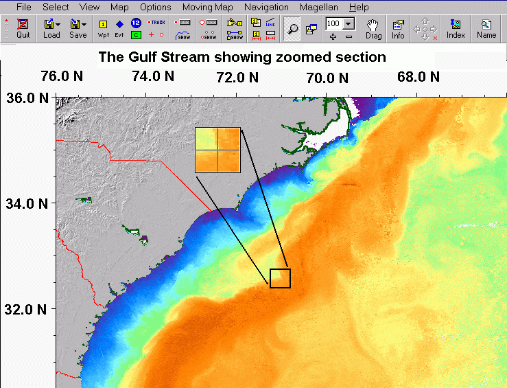
For
analyzing ocean currents in the Atlantic and Pacific and
especially Gulf Stream current where it starts in Yucatan
Channel and Gulf of Mexico, through the Florida Straits
and then flows north along the US East coast and
eventually northeast and east to the North Atlantic. I
use near realtime velocity and SST and SSH satellite
altimetry imagery and computer model forecast imagery. I
obtain my near realtime imagery from several sources
including NOAA, John Hopkins University, Rutgers
University and US Naval Oceanographic Office. We can thus
obtain extremely high resolution, near real time images
of Gulf Stream and it's adjacent eddies and currents. I
use specialized software to display, magnify, and grid
the high resolution images to define features and setting
waypoints. Using high resolution, near realtime images
and graphics software I can see and analyse individual
current stream elements, (temperature, direction,
velocity, size, etc), and am able to recommend routing
and waypoints with an accuracy usually to better than 2-3
nautical miles. With Gulf Stream current axis usually
running at 4-6 knots and its numerous warm and cold
eddies spiraling clockwise and counter-clockwise on both
sides of the Gulf Stream current, this level of precision
makes a big difference in reduced passage and race finish
times. The Gulf Stream weather can be highly
unpredictable and subject to winds and instability in the
atmosphere over and adjacent to the Gulf Stream.
 I have been
providing weather routing to yachts globally since 2003.
I have excellent communications resources, using voice,
email, telephone, cellular, satellite phone, and SSB,
(ham or marine). The most frequent vessel communication
system now is satellite phone vs HF radio. HF radio has
fallen into disfavor. The best communication method is
email vs voice. Email has many advantages over voice.
Iridium is the most popular satellite service. It is
global in coverage, very reliable and not that expensive.
If you have HF email capability onboard and use Sailmail
or Winlink we can certainly communicate by HF email. My
years of passage planning, offshore sailing, routing and
weather forecasting resources and experience are
available to you. Having a weather router with my
combination of offshore sailing, weather, routing,
communications and knowledge of the popular world
cruising routes and destinations, can make a huge
difference in the safety, speed, comfort and efficiency
of your passages. I will be happy to talk about your
planned passage, weather, routing options and answer any
questions you may have. I have been
providing weather routing to yachts globally since 2003.
I have excellent communications resources, using voice,
email, telephone, cellular, satellite phone, and SSB,
(ham or marine). The most frequent vessel communication
system now is satellite phone vs HF radio. HF radio has
fallen into disfavor. The best communication method is
email vs voice. Email has many advantages over voice.
Iridium is the most popular satellite service. It is
global in coverage, very reliable and not that expensive.
If you have HF email capability onboard and use Sailmail
or Winlink we can certainly communicate by HF email. My
years of passage planning, offshore sailing, routing and
weather forecasting resources and experience are
available to you. Having a weather router with my
combination of offshore sailing, weather, routing,
communications and knowledge of the popular world
cruising routes and destinations, can make a huge
difference in the safety, speed, comfort and efficiency
of your passages. I will be happy to talk about your
planned passage, weather, routing options and answer any
questions you may have.
Sail smart.
Sail safe. Sail fast!
Cheers...Capt
Bob
|


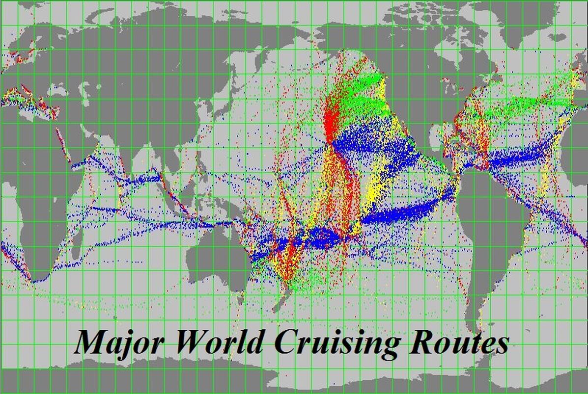
 Every yacht or ship planning an
extended offshore passage needs good weather forecasting,
departure timing and optimal route planning. This
includes sailing yachts, motor yachts, trawlers, mega
yachts and super yachts, any yacht planning an extended
offshore, transAtlantic or transPacific voyage. Yachts
participating in transAtlantic or transPacific rallys can
use Ocean-Pro Weather forecasting and route planning
expertise for safey, comfort, speed and route efficiency.
Popular transAtlantic and transPacific rallys include the
ARC Rally sponsored by the World Cruisng Club, Atlantic
Rally for Cruisers, Caribbean 1500, ARC USA, ARC Europe,
World ARC), the Baha HaHa Rally and the Pacific Puddle
Jump Rally sponsored by Latitude 38 magazine and the
Salty Dawg Rallys. We are one of the sponsors for the
popular transPacific
Every yacht or ship planning an
extended offshore passage needs good weather forecasting,
departure timing and optimal route planning. This
includes sailing yachts, motor yachts, trawlers, mega
yachts and super yachts, any yacht planning an extended
offshore, transAtlantic or transPacific voyage. Yachts
participating in transAtlantic or transPacific rallys can
use Ocean-Pro Weather forecasting and route planning
expertise for safey, comfort, speed and route efficiency.
Popular transAtlantic and transPacific rallys include the
ARC Rally sponsored by the World Cruisng Club, Atlantic
Rally for Cruisers, Caribbean 1500, ARC USA, ARC Europe,
World ARC), the Baha HaHa Rally and the Pacific Puddle
Jump Rally sponsored by Latitude 38 magazine and the
Salty Dawg Rallys. We are one of the sponsors for the
popular transPacific